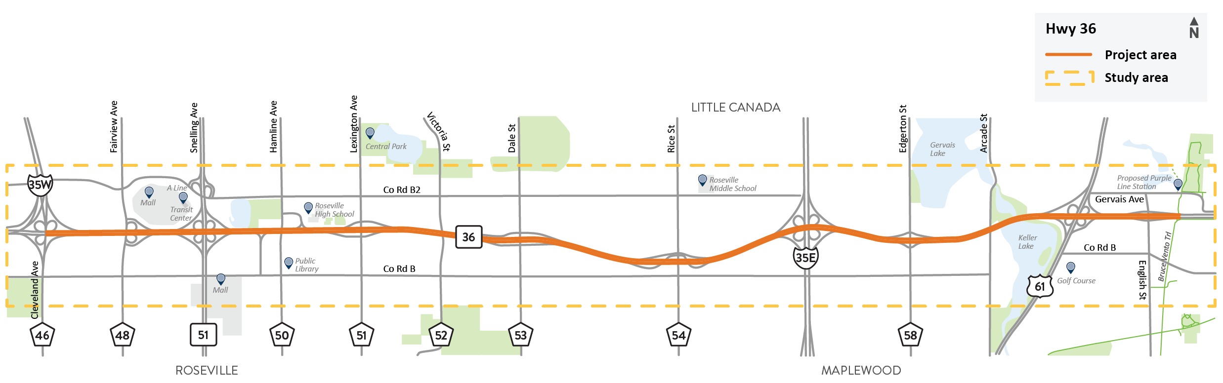
We have completed a planning study of an 8-mile segment of Hwy 36 in Roseville, Little Canada and Maplewood. We conducted this study so that future projects can meet the needs of the people who travel along Hwy 36 by car or truck or travel across Hwy 36 by car, truck, bus, bike or on foot.
We studied this segment of Hwy 36 so that future projects can be designed and planned to better meet the needs of people who travel along and across Hwy 36, including commuters, shoppers, students and local residents. The study addressed the transportation needs of people traveling in motor vehicles along Hwy 36 and people traveling across Hwy 36 by car, transit, bike and on foot.
Summary of work
Reported on existing conditions
Asked people to share their transportation needs
Produced a Purpose and Need Statement that describes existing and future problems
Brainstormed new ideas (alternatives) for long-range improvements
Evaluated these ideas through technical analysis and public input
Described the most promising ideas and next steps
Study findings
Who we heard from
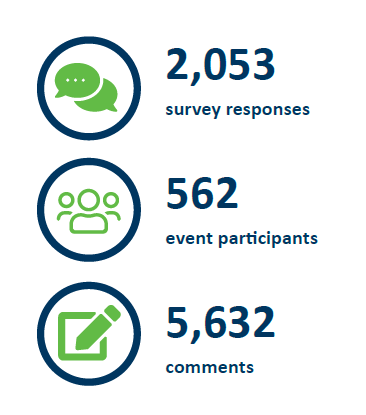
We conducted two rounds of public engagement to ask people what their transportation needs are within the study area and how well they thought different types of improvement would meet those needs. During 2023 and 2024, we reached more than 2,600 people through online surveys, public meetings, community presentations and pop-up events at local businesses.
Transportation needs
This study used public input and technical data to learn the transportation needs of people in the study area. These needs are summarized below. Detailed information is provided in the Purpose and Need Statement (PDF).
Primary needs
Vehicle safety: Reducing severe and fatal crashes
What the data showed: Hwy 36 and ramps have above average rates of crashes resulting in death or serious injury.
What we heard from the community: Improving safety in general is a top priority for most study participants. Merging between I-35W and I-35E was frequently mentioned as a concern.
Vehicle mobility: Improving travel times, reliability and access for people in cars, trucks and transit vehicles
What the data showed: Hwy 36 is often congested during peak travel times and is expected to worsen in the future.
What we heard from the community: Reducing driving congestion along Hwy 36 is a top priority, especially between I-35W and I-35E.
Secondary need
Walkability/bikeability: Improving safety, comfort and access for people crossing Hwy 36 on foot, by bicycle and on transit
What the data showed: Walking and biking are inconvenient, uncomfortable and/or unsafe—especially in high demand locations such as Snelling and Hamline avenues and Rice St.
What we heard from the community: Need better sidewalks and bike lanes across Hwy 36, especially for people going to and from Rosedale Center, Har Mar Mall, Ramsey County Library and Roseville High School.
Alternatives
The study considered many improvement alternatives to meet the needs. Through technical screening, five alternatives for the Hwy 36 mainline were found likely to meet the needs and are being recommended to be carried forward into the next steps of project development. In addition, measures to improve the quality of the crossings of Hwy 36 for cars, pedestrians and bicyclists were also recommended to be carried forward for better safety and comfort of those users.
Hwy 36 mainline alternatives:
Alternatives 2 and 4 were not carried forward because they didn’t meet the transportation needs.
Add one E-ZPass lane in each direction (increases total width from 4 to 6 lanes)
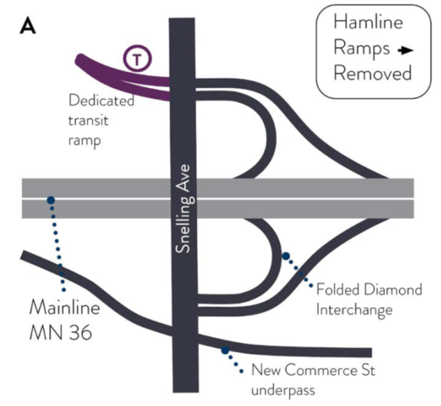
Folded diamond interchange at Snelling Ave.
Commerce St. connection under Snelling Ave.
Hamline Ave. ramps to/from Hwy 36 closed
Add one E-ZPass lane in each direction (increases total width from 4 to 6 lanes)
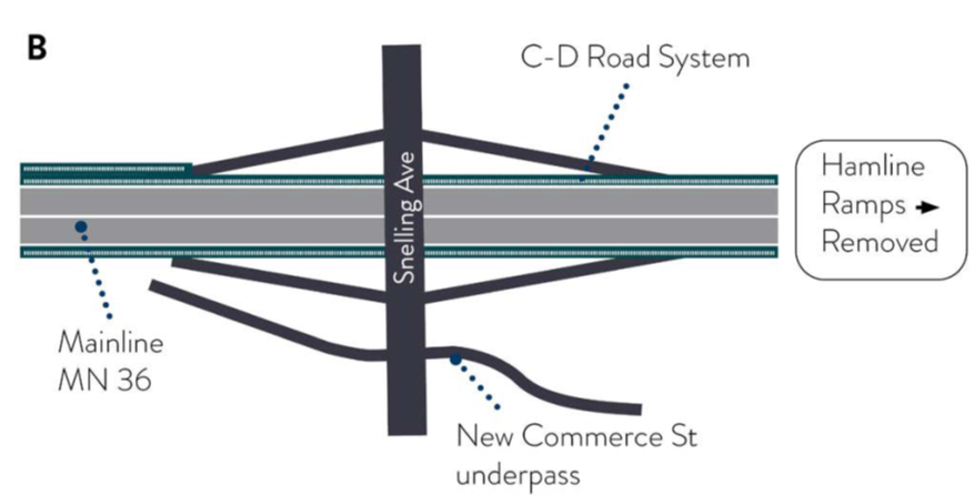
Tight diamond interchange at Snelling Ave. with Commerce St. connection and collector-distributor roads
Commerce St. connection under Snelling Ave.
Hamline Ave. ramps to/from Hwy 36 closed
Add one E-ZPass lane in each direction (increases total width from 4 to 6 lanes)
Folded diamond interchange at Snelling Ave.
Commerce St. connection under Snelling Ave.
Hamline Ave. ramps to/from Hwy 36 remain open
Add auxiliary lanes for longer merging and existing at ramps where needed (increases total width from 4 to 6 lanes in about half of the study area)
Folded diamond interchange at Snelling Ave.
Commerce St. connection under Snelling Ave.
Hamline Ave. ramps to/from Hwy 36 closed
Add a general purpose lane in each direction (increases total width from 4 to 6 lanes)
Folded diamond interchange at Snelling Ave.
Commerce St. connection under Snelling Ave.
Hamline Ave. ramps to/from Hwy 36 closed
The interchange concept for Snelling Ave. for Alternatives 1A, 3 and 5 include:
Folded diamond interchange at Snelling Ave.
Commerce St. connection under Snelling Ave.
Hamline Ave. ramps to/from Hwy 36 closed
The interchange concept for Snelling Ave. is the same for Alternative 1C with the exception of the Hamline Ave. ramps remaining open.
The interchange concept for Snelling Ave. for Alternatives 1B includes:
Tight diamond interchange at Snelling Ave. with Commerce St. connection and collector-distributor roads
Commerce St. connection under Snelling Ave.
Hamline Ave. ramps to/from Hwy 36 closed
Concepts for improving the quality of roads, sidewalks and bike lanes at the 11 north and south crossings of Hwy 36 are also recommended to be carried forward for further project development. These include such features as:
Sidewalks on both sides of the street
Crosswalk improvements such as flashing beacons, better striping, shorter distances
Pedestrian refuge islands
Slower-speed intersection designs
Curb extensions
Buffered or barrier-separated bike lanes
What comes next
This study has provided information and ideas to help guide the planning of future improvements along and across Hwy 36. There are many next steps to address, including more detailed designs and refinements of alternatives, environmental reviews, costs and funding and partner roles. We will continue meeting with communities and leaders to develop projects that meet the needs of the people in the study area.