Highway 55 roadwork in Annandale begins April 21
ST. CLOUD, Minn. – Motorists who travel on Highway 55 through Annandale, Wright County, should prepare for delays as roadwork begins on Monday, April 21, advises the Minnesota Department of Transportation.
The $11.5 million project will resurface, reconstruct and widen shoulders on segments of Highway 55 from Brown Avenue to east of Annandale Boulevard, which includes underground city utilities, sidewalks and adjacent roads/entrances (Figure 1).
Here’s what to expect on Highway 55:
Annandale Boulevard to Poplar Avenue: Open to two-way traffic
- April 21 to late April—Prepare work areas: temporarily widen shoulders along the south side of Highway 55 for future traffic lane shift, set up equipment, road devices, etc. Minimal impacts and shoulder closures.
- May to mid-October—Widen road along north side, pave, add center turn lane and update storm/ditch drainage. Expect narrow lanes and two-way traffic with no shoulders.
Brown Avenue to Poplar Avenue: Closed to through traffic
- Late May to mid-October: Reconstruct road; replace or update underground utilities, includes city water, sewer and storm water; replace signals at Excelsior Avenue; realign to improve access at Highway 24 and install a flashing pedestrian crosswalk; realign to improve access at Poplar Avenue S, close west end Service Road entrance and install a cul-de-sac; update or add pedestrian sidewalk along both sides of Highway 55 from Brown Avenue to Cherry Street and the north side to Service Road; and update street lighting.
- Detour: Highway 55 will be closed to through traffic between Poplar Avenue and Brown Avenue. Motorists will follow a detour that uses Wright County Road 3, County Road 39, Highway 24 and County Road 6.
Local traffic: Annandale is open
- Access will be open and maintained to those who live, work or visit within the closed work zone. Expect reduced speeds, changes to access, gravel or grooved road surfaces, narrowed lanes, lane shifts, flaggers, heavy equipment and use of alternate accesses. Please slow down, follow construction signs through the work zone and stay out of barricaded areas.
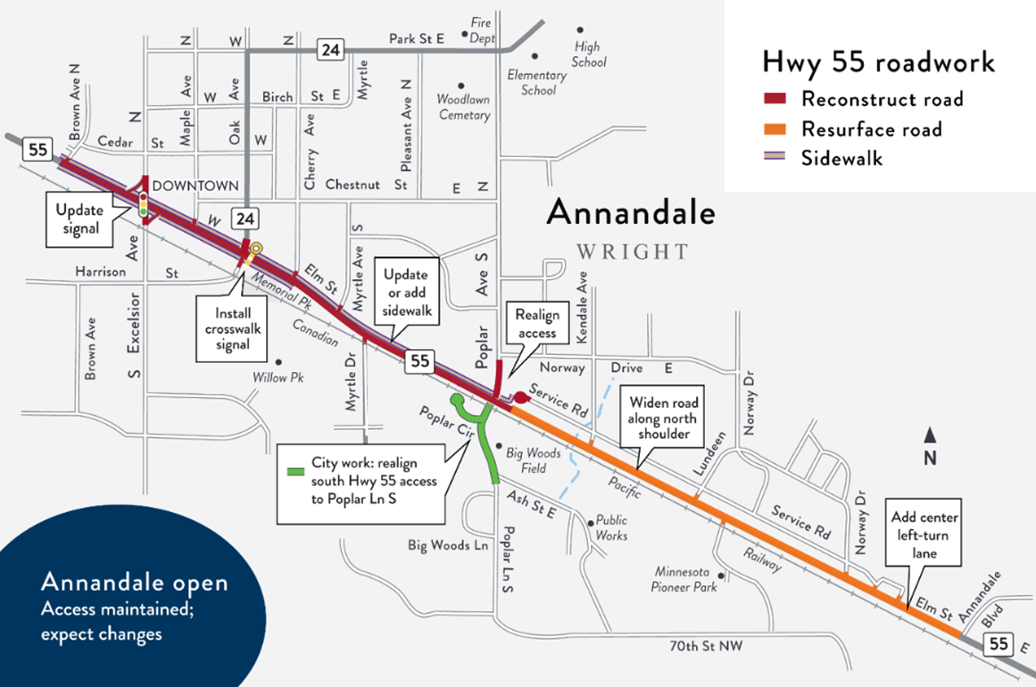
Figure 1: Highway 55 work, location map between Brown Avenue and Annandale Boulevard (PNG)
When complete in mid-October, travelers will benefit from a smoother ride; improved motorist and pedestrian access and safety; and updated drainage and city utilities.
For more information, to view detour maps, sign up for email updates or contact MnDOT, visit the project webpage: www.mndot.gov/d3/projects/annandale.
For current road conditions and detours on Minnesota highways, visit 511mn.org or get the free smartphone app at Google Play or the App Store.
# # #